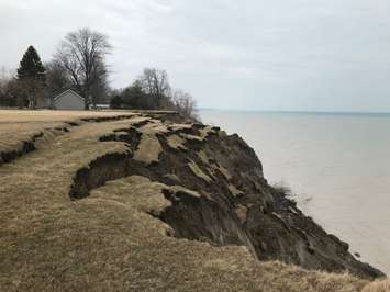
The Municipality of Chatham-Kent is prioritizing the most vulnerable areas along the Lake Erie Shoreline when it comes to protecting against erosion and flooding.
On Monday night, council received the final report from the Chatham-Kent Lake Erie Shoreline Study, which looks at the Lake Erie shoreline from Wheatley to the municipal boundary near Clearville and the impact that climate change is having on the shore.
Described as the first of its kind in Ontario, the study took nearly two years to complete with the final report coming in at 181 pages.
Geoscientist Peter Zuzek presented the final findings to council, predicting some potentially grim outcomes for the shoreline down the line and some costly solutions. The implementation of the solutions suggested in the report would result in a capital cost ranging from $131.7 million to $217.2 million, plus annual maintenance.
A few of the protective concepts for some of the most at-risk areas include a 3.3-kilometre armour stone revetment along Erie Shore Drive, costing at least $46.2 million. To protect Talbot Trail from devastating erosion, Zuzek is recommending re-aligning a portion of the roadway inland at a cost of $34.7 million.
After receiving the information, council voted in favour of focusing on the most vulnerable sections of shoreline in the municipality first: Erie Shore Drive, Erieau Road, Talbot Trail and Rose Beach Line.
For Erie Shore Drive, that includes developing a long-term plan for the roadway following the drainage act to develop community-scale shoreline protection and dike upgrades.
"The act is a communal process which allows property owners to gain access to drainage or other drainage related features that will help them improve their properties," explained Tim Dick, Chatham-Kent's director of drainage. "The concept is that in doing so, they will pay their fair share but in addition, others who are affected or are deemed to benefit will pay their share as well. The process is such that drainage act works are initiated through a petition under the act. It's a legal process by petition... the petition process allows property owners rights."
Once a petition is received by the municipality, a drainage engineer will be appointed to initiate a preliminary report.
Dick noted that it would take at least two years for the drainage act process to unfold, calling the Erie Shore Drive project the most complicated one that he's seen in his career.
"To expect it to happen in a very short timeframe is very unrealistic. It's a step by step process where you've got the get a petition in place, appoint an engineer, move forward with the on-site meeting and follow the process," he explained.
For Talbot Trail, an environmental assessment will be completed looking at the possibility of realignment, which will then come back to council. An environmental assessment is also being requested for Rose Beach Line. Meanwhile, on-going maintenance will continue to protect the dike along Erieau Road opposite St. Anne's Church. In addition, administration will work in the long-term toward a strategy for the remaining regions featured in the study.
The staff report notes that there is currently no funding available from upper-levels of government. However, council also approved a recommendation that the municipality continues to seek funding from the provincial and federal governments to assist with flooding and erosion challenges. Administration will also initiate discussions with the provincial government to obtain a commitment and funding to restore the Rondeau barrier beach.
Gord Quinton, chief financial officer, said it would be impossible for homeowners and/or the municipality to fund the fixes on their own.
"We need partners at the federal and provincial level to make all these actions feasible," he said.
Councillor Melissa Harrigan successfully added an amendment requesting that staff also return to council with a report that identifies opportunities and programs that the municipality can make available for homeowners living along the most vulnerable areas of the shoreline to protect their properties.
To read the complete Zuzek study and the recommendations, click here.