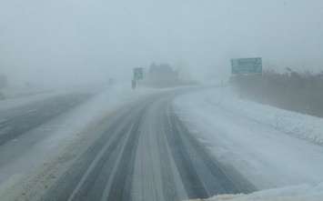
The winter storm that is rolling into southwestern Ontario will look more wet than white in areas along Lake Erie.
Environment Canada issued a special weather statement for London-Middlesex, Sarnia-Lambton, Chatham-Kent, Windsor-Essex, Elgin County, and Oxford County on Monday, calling for a mix of snow and rain beginning early Tuesday.
Forecasters have since upgraded that statement to a rainfall warning for an area stretching along Lake Erie from Windsor to Niagara Falls. Rainfall amounts of 20 to 35 millimetres are expected in communities in that area, which includes Chatham-Kent.
The rain could also lead to some ponding of water on the roads and localized flooding in low-lying areas.
Further north, Sarnia-Lambton and the London-Middlesex area are still under a special weather statement.
The snow may be heavy at times before changing to rain near midday.
"Local snowfall amounts near [five] cm are possible before the changeover to rain. Latest analysis suggests that 20 to 30 mm of rain is likely before tapering off Tuesday night," said the national weather agency in a statement.
With temperatures near freezing, there is a chance of wet snow making driving conditions slushy and hazardous.
The special weather statement is expected to remain in effect until Tuesday evening.