The St. Clair Region Conservation Authority (SCRCA) has issued a flood warning after the watershed received upwards of 20 millimetres of mixed precipitation over the last two days.
The conservation authority said the recent precipitation and warmer temperatures led to melting snow and ice, which resulted in increased runoff throughout the region.
"Below freezing temperatures [Thursday] and overnight will slow further snowmelt and ice loss, however, this stored water will start to work its way through the system over the next five days when temperatures begin to fluctuate," read a media release.
The SCRCA said water levels on the east branch and the upper reaches of the north branch of the Sydenham River have started to level off, and water levels along Bear Creek and Black Creek, south of Petrolia, continue to rise slowly but should begin stagnating over the next six to eight hours.
Residents are reminded to avoid watercourses and flooded areas because of dangerous and unstable ice conditions, slippery banks, and swift moving water.
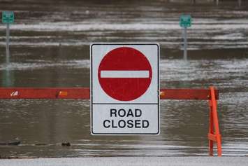
Flooding has affected the following roadways:
- Plowing Match Road between Petrolia Line and Rokeby Line in Enniskillen Township
- Pretty Road between Stanley Line and McCallum Line in Wilkesport have been impacted by flooding.
The flood warning is expected to remain in effect until 12 p.m. on March 10.
The Ausable Bayfield Conservation Authority also issued a flood warning Thursday afternoon.
The conservation authority said recent weather conditions have caused an ice jam in the Port Franks Harbour, causing local flooding to the Port Franks marinas, Superior Street, Biddulph Street, Patrick Street, and Riverside Drive.
The Ausable Bayfield Conservation Authority's flood warning message will remain in effect until 9 p.m. on March 8.