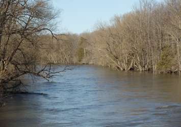
The St. Clair Region Conservation Authority has issued a flood watch as water levels continue to rise throughout the region.
According to the SCRCA, water levels are beginning to peak mid-watershed and are continuing to rise in Wallaceburg. The water levels are elevated into natural floodplain areas, parks and farm fields.
The ground is some ares is expected to be wet and could create ponding, increased runoff into watercourses, and possible increased erosion and seepage issues.
Westerly winds ranging from 20-30 km/h are expected to peak at 40km/h. These winds have the potential to cause a backwater effect in the Wallaceburg area, further elevating water levels.
The SCRCA warns that the rising water levels may affect certain roads. These roads include Stanley Line between Kimball Road and Waubuno Road, Pretty Road north of McCallum Line, and Waterworks Road north of Courtright Line.
River banks are expected to be slippery, with possible minor erosion. Residents are reminded to avoid slippery water banks. Children and pets should be kept away from the water.
The watch is in effect until Tuesday.