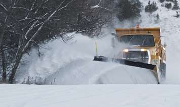
Colder than normal temperatures, snow, and gusty winds will make for messy conditions across Sarnia-Lambton.
Environment Canada said lake effect snow off Lake Huron could dump 15 to 30 centimetres of snow across the region beginning Wednesday afternoon into Thursday.
Warning Preparedness Meteorologist Geoff Coulson said initially, higher snowfall amounts are expected east of Sarnia.
"There will be some accumulation in the Sarnia area but probably of lesser amounts, 10 to 15 potentially, maybe even a little less than that depending on where the bands do set up," said Coulson. "But, it will be further east in those areas like Petrolia, Forest, Watford, Strathroy, they're likely to be locked into these heavier snow bands for longer, and those areas could be looking at the potential for 30 plus centimetres by Thursday afternoon."
Coulson said along with the heavy snow, winds out of the northwest up to 60 kilometres per hour and blowing snow will result in reduced visibility.
"Probably the heaviest snow squalls developing Wednesday evening, but that activity will continue overnight and likely will persist in many areas through Thursday morning. Some of the forecast models indicating the worst of lake effect activity finally pushing out of eastern Lambton County late Thursday afternoon. So, we could be looking at a fairly prolonged event in some areas."
Motorists are being advised to prepare for quickly changing and deteriorating travel conditions.
West Region OPP Sgt. Ed Sanchuk said drivers should plan ahead and slow down.
"Take your foot off the gas pedal, ensure that your vehicle is entirely cleared off of all ice and snow, and with the temperature drops, be aware there could be some freezing as well," said Sanchuk in a social media post.
A much colder band of air from northern Ontario will also result in a dramatic drop in temperatures to well below seasonal.
"In the Sarnia area, the temperature is expected to dip down to minus 6 Celsius by late Wednesday afternoon, and an overnight low wakeup temperature Thursday morning of only minus 12 Celsius," said Coulson. "And when we factor in the wind, we're looking at wind chills for those wake up temperatures Thursday morning of around minus 23 Celsius."
The forecasted high for Thursday in Sarnia is minus 9 C.
Coulson said the normal high for this time of year locally is around minus 2 C.
*Update: The snow squall warning ended for Sarnia shortly after 2 p.m. on Thursday.