The St. Clair Region Conservation Authority (SCRCA) has issued a flood outlook for the watershed.
It says rain Thursday and Saturday combined with warmer weather over the next several days is expected to cause water levels to rise in area rivers and streams.
Temperatures are forecast to reach around 10 C on Friday, remain warm overnight, and then climb to a high of 18C by Saturday afternoon.
The SCRCA anticipates this will melt most, if not all, of the remaining snow in the watershed.
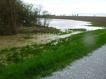
The conservation authority said the ground is saturated and has low ability to soak up water. Rain and snowmelt will quickly run off into local watercourses.
Water is expected to overflow into low-lying areas that usually flood in the spring. Some watercourses have started to show signs of rising.
The SCRCA expects water levels to continue to rise gradually and remain elevated into next week.
We're reminded to avoid watercourses and flooded areas due to dangerous conditions, slippery banks and cold swift moving water, and to keep children and pets away from the water.
The SCRCA's coverage area includes the Sydenham River watershed and smaller watersheds draining directly into southern Lake Huron, the St. Clair River and northeastern Lake St. Clair.