Snow squalls are forecast in Sarnia-Lambton for the start of the first full week of 2016.
Environment Canada issued a watch for the entire county early Sunday morning and then upgraded that to a warning for Watford, Pinery Park and eastern Lambton County.
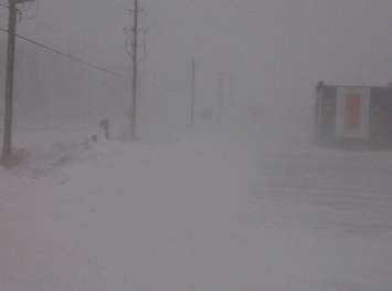
By early Sunday afternoon persistent snow squalls had developed with visibility rapidly reduced at times due to heavy snow combined with blowing snow.
Snow squalls were moving ashore off Lake Huron from south of Point Clark to Grand Bend and extending inland to form one main squall just west of London and into St. Thomas. Snowfall accumulations in the heaviest bands near 10 cm (4 in) were expected Sunday with visibility near zero at times.
The national weather agency says winds will become more northerly Sunday evening causing the snow squalls to shift west of London, impacting Strathroy, Komoka, western Middlesex and Elgin counties, Rodney, Shedden as well as Pinery Park, Watford and east Lambton County into Monday morning. Local snow accumulations in excess of 15 cm (6 in) are possible.
Travel is expected to be hazardous due to reduced visibility in some locations and road closures are possible.
A snow squall watch continues for Sarnia, Petrolia and western Lambton County
Lake effect flurries are expected to develop after midnight and intensify to snow squalls backed by brisk northwest winds.
Local snow amounts of 10 cm to 15 cm are possible.
The snow squalls will weaken Monday afternoon.