The St. Clair Region Conservation Authority has upgraded its Watershed Conditions Statement to a Flood Watch.
It said on Monday about 15 to 50 millimetres of rain fell across the region and the ground was already saturated due to rain the watershed experienced last week.
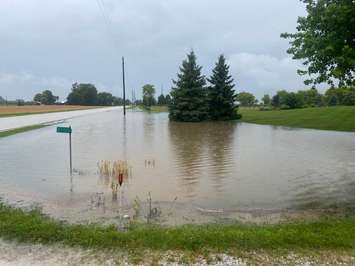
On Tuesday, torrential rains and thunderstorms dumped an additional 10 to 30 mm of rain with upwards of 50 mm in localized areas.
As a result, the conservation authority said water levels are expected to remain high due to the increase in runoff. Localized flooding in low-lying areas; floodplain, agricultural and parkland is anticipated.
Several roads in St. Clair Township may be impacted by flooding including:
-Stanley Line between Kimball Road and Waubuno Road
-Wabuno Road between Bickford Line and Oil Springs Line
- Pretty Road north of McCallum Line
- Waterworks Road north of Courtright Line
-Telfer Road between Courtright Line and Moore Line
Residents, children and pets are urged to stay aware from watercourses and flooded areas due to dangerous conditions, slippery banks and cold, swift moving water.
The conservation authority said it continues to monitor watershed conditions and will issue advisories to municipalities and media should flood issues arise.